What are those new cameras on Hamilton Boulevard traffic signals?

So, what are those new cameras on Hamilton Boulevard traffic signals?

The cameras being installed along a sequence of signals on the Boulevard are part of the hardware package for the townships new traffic adaptive “smart” system. It’s not yet activated but will be later this summer.

They will be used by the automated adaptive system to “sync” green light and turning lane phases corridor wide. Each signal will communicate in real time via a wi-fi system to coordinate traffic flow.

Here is a very nice overview of a similar system.

Township adopts Rt. 222 visioning study.

The township recently adopted by unanimous vote a planning/visioning document for the Rt. 222 corridor.  A week later Upper Macungie adopted the same document.

Overview:
5 miles in length, the Hamilton Boulevard Study Area extends from US 222 at the western gateway to I-78 at the eastern gateway. The study was the result of a two year process initiated by Lower & Upper Macungie Townships, with the support of PennDOT, to coordinate transportation and land use policies across municipalities lines.

Before I get further into why I think the corridor study is so important, let me first outline what I believe is the fundamental problem it addresses.

The Problem:
We have a tax base resiliency issue in Lower Macungie. This is based on a reality where certain land use patterns we are heavily invested in for better or worse generate relatively low returns vs. the high impact long term infrastructure liabilities we must assume + increased demands for service. This represents a fundamental imbalance. For too long land use choices have represented transactions of decline. But much like a ponzi scheme the problems have been masked by one time windfalls associated with the growth.

All this compounded by the fact Harrisburg mandates a rigidly inflexible taxing system leaving us no way to right size levies on land uses based on their measurable impacts.

As we approach buildout and one time windfalls associated with greenfield growth slow to a trickle our imbalance will become pronounced. Inevitably, developer money moves on to the next cornfield. Federal and state finances will likely worsen and access to grants will be increasingly limited. Lower Macungie’s tax base will be insufficient to pay for our liabilities.

Gerald Cross – PA municipal league. Quiet boom & bust of PA townships

Reality is we have..

  1. An inflexible taxing system mandated by the state.
  2. The need to provide a minimum level of service, not necessarily mandated but certainly reasonably expected by residents.
  3. Declining windfalls and township reserves.
  4. A development pattern that leaves a tax base financially insufficient to cover municipal liabilities.

One solution relates to Hamilton Blvd. The townships “Bread basket”.

There are a number of solutions I will be proposing and outlining over the next few months. All based on addressing long term financial resiliency. The one that specifically relates to the Boulevard deals with refocusing on financially positive land development patterns and away from low value sprawl. At it’s core it’s a structural framework that the vision outlines.

Hamilton Boulevard should be looked at as the townships “bread basket”.

Why? Because significant public investments have already been made over the years. The adjacent location next to the bypass (even with all it’s design warts) make it THE prime location for higher value development to offset the low value development west of Rt. 100.

The study lays the groundwork conceptually. Of the dozens of recommendations made, there are some folks who will inevitably focus on high cost big ticket items in the plan. This is unfortunate. Those items get the headlines but they shouldn’t be the focus at all. They are in the grand scheme a small part of the vision. They may be tackled someday. Or they might not be. Today, we focus on the low cost / high return incremental strategies outlined. That is where the beauty of the plan is. The most important reforms relate to policy and will cost the township nothing. Other improvements will cost the township very little.

For example, we need to remove regulatory barriers in order to attract higher quality development that is more community friendly. There in the long term more valuable. This related to built form. Pictured below are some examples. The first example happens to be an old building, but as demonstrated in the following photos we can (and many developers are) building new construction like this! Many communities are doing just that. The problem is that a developer can’t build a building like this. Because of arbitrary regulations it’s actually illegal without seeking costly variances.

That is a shame since the traditional development patterns still today offer some of the highest possible municipal returns.

Ingredients for a high value commercial corridor? Quality High Value Safe Financially productive and resilient.

Ingredients for a high value commercial corridor?
Quality
High Value
Safe
Financially productive and resilient.

Screen Shot 2015-09-09 at 4.57.37 PM

Friendly, high value. Safe. This is a Main Street arterial. The volumes are comparable to Hamilton Boulevard. Yet, the streetscape has a friendly tone. More like “Main Street” then “Macarther Rd.”

Screen Shot 2015-09-09 at 5.09.07 PM

Not just little shops and restaurants. This is a bank with a drive through.

Screen Shot 2015-09-09 at 5.05.55 PM

And here is a community friendly Rite Aid on a tree lined street very similar to Hamilton Blvd. Today, our zoning regulations actually prohibit this type of building.

Warehouses are the extreme other end of the spectrum. Immense buildings that gobble of up massive acreage of prime farmland. These buildings return very little to the community and in terms of new liabilities created are essentially fiscal parasites on a townships tax base. 

Our township has an imbalance of this sort of land use. Low Value. Low jobs/acre Low revenue/acre Extreme high liability

Our township has an imbalance of this sort of land use.
Low Value.
Low jobs/acre
Low revenue/acre
Extreme high liability

Hamilton Blvd vision study.

1. Fostering a distinct sense of place. We must draw a line. The Boulevard will not be another “Macarther Rd.” We must demand and expect high quality high value development.2. Promote voluntary inter-muncipal cooperation. The future of the Boulevard depends on Lower Macungie’s ability to work in partnership with Penndot, Upper Macungie and the regional advisory planning body.

3. Identify and prioritize road improvements. Further expanding on existing investments.

4. Create a multi-modal place. This must over time develop into our our “Main Street”. This cannot devolve into the low value strip corridor trap.

  1. We must maintain balance. To cash in on our investments, we also must De-STROAD-ify the Boulevard & Bypass.

5. Encourage high value smart growth land use patterns with financial high returns as a counterbalance to low value development west of Rt. 100. Discourage low value and low return patterns.


Avoid statistically inevitable outcomes…

We cannot ethically continue to design roads in a way we do not give pedestrians and drivers a fighting chance to avoid tragedies.

Current speed limits in many Lehigh Valley town centers simply do not give folks a fighting chance. That was the case was in Emmaus in May. The 11 year old who lost her life wasn’t the only victim. The elderly driver who has to live with this is also a victim. An investigation ruled correctly the driver was not at fault. The driver was obeying the posted speed limit.

Statistical reality caught up with us in the Borough that day. The same will happen in Macungie as it’s inevitable with the current design of Main St.

In Emmaus, the 11 year girl was an unforeseen variable. Problem is 11 year olds tend to do that. No matter how well raised. So do elderly, the disabled, pets, someone who leaves a restaurant and had a glass of wine with dinner. I can go on and on but you get the point.

By nature and by design town centers are full of unpredictable variables. (that comes with density) They are complex environments. It’s what makes them special places. Within them not everyone behaves in a predictable manner. This is a baseline. It is. You cannot change it. We have to accept it.

What can we change?

We can change the speed limit. We can change the road design to match the speed limit. The “inconvenience” factor relating drivers is negligible to non-existent.  Let’s quantify.

IF Chestnut St. was a straight shot with no stops, driveways, crosswalks etc. and considering the “business district” is 1 mile in length.

1 mile travel time: (roughly the length of Emmaus business district)
35 MPH – 1:45 seconds mile
25 MPH – 2:24 seconds to go 1 mile

Under the best (unlikely) scenario the difference is 39 seconds of travel time. Of course the route isn’t a straight shot. The road has traffic signals, crosswalks and driveways. Statistical reality is that your almost never going to have that “straight shot” through town. Therefore, accelerating to 35 mph for brief periods of time to get from one obstacle to the next won’t get you somewhere 39 seconds faster. Reality is  it’s just a few SECONDS quicker if anything at all. Not to mention the incredibly inefficient waste of gas/wear and tear on your automobile that comes with rapid accelerations/decelerations. And just the plain stupidity of accelerating from red light to the next.

On the flip slide there is an irrefutable and direct correlation between a 10 mph speed reduction and a reduction of both the frequency and severity of accidents. From 25 to 35 mph the death rate DOUBLES. (Triple A foundation for traffic studies) Full stop. Again, from 25 to 35 mph the death rate DOUBLES.
Screen Shot 2015-07-28 at 11.06.59 AMGive everyone a fighting chance.
First, it’s my opinion you take the “convenience” of drivers where in measurable terms equals mere seconds of drive time completely out of the equation. It is an asinine argument. It’s also an inflated argument where perception isn’t reality. But let’s say it was. To think seconds of your time is worth putting yourself and everyone around you at higher risk is incredibly selfish and tragic.

Visual perception at different speeds.

Visual perception at different speeds.

Reducing the speed limit on Main St. Macungie (35 to 25) Chestnut street in Emmaus (35 to 25) and Hamilton Boulevard in Lower Macungie (from 40-45 to a consistent 35mph) needs to happen now. Followed by aggressive traffic calming strategies so the physical design matches the posted speeds.

I know for a fact Macungie Borough, Emmaus Borough and Lower Macungie Township have all requested over the years lower speed limits on Chestnut, Main St. and the Boulevard. The problem each time from what I understand is Penndot. Somewhere there is a disconnect. Penndots own smart transpiration guidebook outlines a 25 mph desired operating speed on a “Main Street“. In Lower Mac the catalyst for a request was actually Hamilton Crossings shopping center. Clearly,the developers understand slower speeds are good for business and the economy of the upstart Boulevard.

Common sense dictates lowering the speed limits. Standards reinforce it. Local municipalities who know the roads best have requested it. Residents have demanded it. So what is the issue here? When we set operating speed too high we have a statistical inevitable outcome of tragedy. 

What we know:

  • Slower speeds are safer for everyone
  • The loss of travel time is negligible to non-existent
  • Slower speeds in town centers actually ease congestion
  • Slower speed is better for downtown businesses

You can also sum up this entire argument here. ELIMINATE STROADS! As deadly as a STRAOD designed too fast through a Borough is, a STROAD designed with highway geometry seemingly for 55+ mph but posted artificially at 45mph or containing traffic signals is just as dangerous.

Very few roads should be posted between 35mph and 55mph. That is the tragedy zone. Design it as a road (get people from A-B) or make it a street (multi modal value capture) But please, STOP BUILDING STROADS.

STROADS: Dangerous Expensive Low return on investment

STROADS:
Dangerous
Expensive
Low return on investment

Big Box becoming more of a terrible deal.

From the Institute for local self reliance: About ILSR
For Cities, Big-Box Stores Are Becoming Even More of a Terrible Deal.

#DoTheMath – Couple of takeaways from this:

1. We have a potential dark store issue in Lower Macungie. Since.
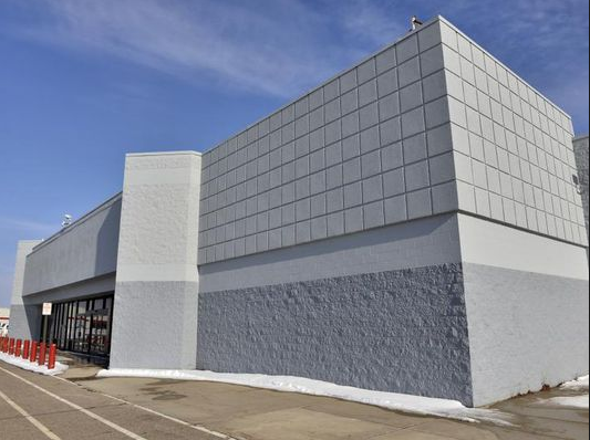
It’s an established part of the big-box retail model that the boxes themselves be custom-built, cheaply constructed, and disposable. If retailers decide that they need a bigger space, it’s cheaper for them to leave the old one behind and build a new one.

This is happening in Lower Mac right now with Weis. They are currently in the process of abandoning their current store to build a new one – across the street. This opens the possibility for Weis to argue the “dark store” method for calculating tax assessment.

Screen Shot 2015-06-18 at 10.37.28 AM

2. Even without assessment reductions box retail isn’t a fiscal winner for local communities. The reduction strategies happening in some states just make it worse.

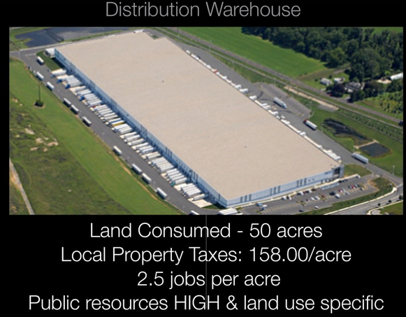
When eight communities in central Ohio looked at the fiscal impacts of big-box retail, they found that the stores actually demanded more public services than they generated in revenue, and created a drain on municipal budgets to the tune of a net annual loss of $0.44 per square foot, or about $80,000 for a typical Walmart supercenter. 

Mark my words, our increasingly boxy/strippy Hamilton Corridor will be the driver for local police and a massive unavoidable tax increase: 

“Higher demand for police departments is one example. In Port Richey, Fla., nearly half of the town’s crime emanates from the area Walmart. “The taxes that come from Walmart are not even enough to cover two police officers’ salaries,” Police Chief Robert Lovering told Vice.”

It’s happening in Lower Mac today.

3. With Hamilton Crossings we are beginning from an even bigger hole. Throughout the HC discussion it was parroted that the windfall was worth the tax gimmick. The narrative was: “There is nothing now, when something is built we can tax it”. Problem is what we approved costs us much more then what’s there now – fallow open space. And the new tax revenue won’t cover the long term liabilities. Our problem is the fatally flawed short term way we look at municipal finances.

“Cities and towns continue to buy into myths sold to them by the mega-retailers themselves, that big-box stores spark economic development. In service of this myth, local and state governments across the country have granted at least $2.6 billion in subsidies to just six large retailers, including $160 million to Walmart and $138 million to Lowe’s, according toanother study from Good Jobs First.  That’s without factoring in the cost of services, which as Marquette, Mich., saw, can pile up”

We got to start thinking beyond the windfall and look at lifecycle sustainability. That is: Lifecycle costs (liabilities) vs. revenue (tax base). I am not arguing for a valuable corridor to be vacant. This isn’t about NIMBY. My argument is a financial one. We need to build better. Smarter. Patterns that create positive value. But since at least with Hamilton Crossings that ship has sailed….

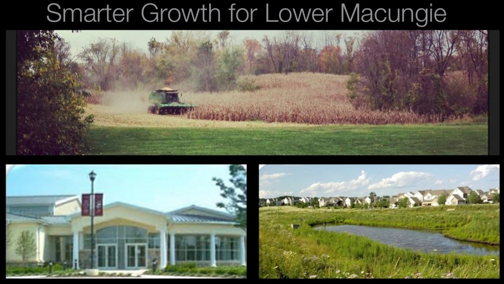
4. Living in reality. What’s done is done.  Can’t change the fact 3 members of the current BOC opted to hand out a 20 year tax subsidy. So, moving forward our strategy has to focus on repair and triage. We accomplish that with balance. First by preserving farmland and open space concentrating on places where expensive infrastructure would have to be built and maintained by taxpayers to support greenfield growth.

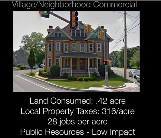
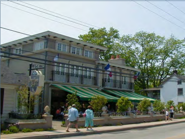
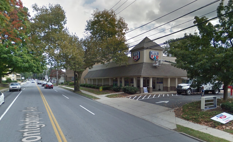
Second, we encourage better/smarter growth in patterns that creates higher value in locations where infrastructure exists. We get there by fixing our terribly archaic and restrictive zoning code. By instituting aspects of a form based code we allow and even incentivize more “Main Street” oriented walkable neighborhood mixed use devleopment on Hamilton Boulevard.

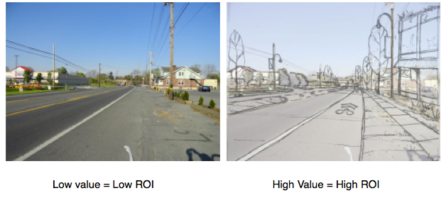
The land development alternative – What does that mean? Lower Mac is working on a vision.  Here is an outline: Lower Mac’s Hamilton Corridor vision study. If we adopt and follow this plan we will induce more high value growth on Hamilton Boulevard. This is essential to balance the low value. More positive growth will help balance the net negative financial development.

“Locally owned retailers provide value to a community in many ways, but one of them is to the municipal accounting books. In a study that found that big-box retail generates a net deficit for taxpayers in a Massachusetts town, the researchers also discovered that specialty retail, like Main Street businesses, are the ones with a positive impact on public coffers, generating more revenue than they require to service.”

One thing to watch is avoiding falling into the pitfalls of “smart growth light” like we have in the past. #WordsHaveMeanings.

Screen Shot 2015-06-18 at 10.49.55 AM

The taxing alternative – Shift the burden off residents and onto warehouses and box stores.

Essential reading as we study Hamilton Corridor.

We’re about to spend 125,000 in grant money to “identify a complete street strategy for the Hamilton Boulevard corridor emphasizing land use changes, public transit, and intermodal amenities“. This is a joint project of Upper & Lower Macungie and Penndot.

I ordered “The Boulevard Book – History, Evolution and Design of the Multiway Boulevard” a couple weeks ago. Last week I was able to start getting into it. Having read through the introduction and first couple of chapters I’ve found it to be a fantastic read.

The intro clearly lays out the value of a true boulevard concept. They are statistically safer and more aesthetically pleasing while increasing property value for adjacent properties. The book contains an immense amount of research and documentation. It also lays out the artificial and flawed reasoning why we no longer build grand avenues and boulevards.

Our commissioners have pledged to build a “world class boulevard”. A concept I am 100% in agreement with. A true blvd. pays close attention to many important concepts. Livability, mobility, safety, economic growth and open space to name a few. The opposite of a blvd. would be a commercial strip. Where a boulevard becomes a living part of the fabric of a community, a commercial strip slashes it’s way through a community killing property values creating congestion and ruining quality of life. A true boulevard is a value capture machine vs. strip arterials which almost always cost more in terms of liabilities then they produce in revenue.

This attractive and very functional boulevard accommodates a lot of traffic,
encourages walking, and still allows for parking in front of the building.

This strip mall on an ‘arterial’ lacks the character of the above boulevard. Most suredly property values are lower across the street from this place. This is not a place where many people would want to walk or spend time in other then in a car going from one place to another.

I will be copying the intro from this book and giving it to our commissioners. I see it as essential reading as we begin the PCTI study. A main point of the book is how today’s design criteria that focuses exclusively on the automobile and incorrect superficial assumptions about what makes a good street inevitably leads us to build statistically dangerous and soul-less places. If we are to build a “world class boulevard”, then we have to get past these roadblocks.

There are so many ingredients that go into a boulevard. Traffic flow, parking, delivery of services, walkers, bikers and of course how frontages interact with the boulevard in a cohesive fashion. 

I believe currently there is a disconnect between what we are saying and what we are doing. It’s no secret I am no fan of recent land development plans that are in my opinion counter to the goals of a blvd. Namely projects like the very “strippy” potential “American Kitchens” tract. Others recently such as “Shepards Crossing” are better considering our low bar but in my opinion we can push the envelope even more.

Yes, there is a learning curve between concept and changing our zoning to match the concept. But in the meantime we can be more aggressive in soliciting buy in from developers. Developers who can then request the appropriate variances to build context sensitive designs. Afterall we gave 88+ variances (some major) to Hamilton Crossings for the potential shopping center. You would think we could grant some to accomodate the goals of the boulevard project.

The Kairos group is the firm contracted to lead the PCTI study. The power point presentation was loaded onto the twp. website. I think alot of the stuff included in the presentation is wonderful. The Kairos group talks about some of the concepts in the boulevard book. For example, the roadblocks to building great places. They talk about the conventional approach vs. a context sensitive approach. I think it is critical to understand these two sometimes subtle but different approaches. The conventional approach is more likely to produce something more like the “strip arterial” above. Vs. the context sensitive approach which is more likely to produce the avenue above.

Here are some examples from the Kairos group that show what Hamilton could look like with a little vision, some regional cooperation and real buy-in by our elected leadership.

Hamilton Boulevard as it currently looks overlayed with an artists rendering of a boulevard concept.

Hamilton and Brookside intersection. Right now at certain times this is a heavily congested mess. A roundabout would allow the intersection to flow much more freely. Roundabouts are also proven to be much safer both for cars and pedestrians. Imagine working in the office buildings on Brookside and actually being able to walk to lunch at Hunan Springs without taking your life into your hands.