Below is a list of properties in the township that I most often get questions about in terms of development potential. In other words, “what can be built here”?
For each, I’ll provide some thoughts on the properties in general and what different scenarios exist for development. Note, unless I indicate that the property is on the adopted official map, or refer to an adopted comprehensive plan these thoughts are my own. This is just a start and I’ll be adding more properties as well and additional updates if and when I get more information. These are all “by right” scenarios assuming that future boards don’t rezone these properties. The current board is very much against wholesale up-zoning of properties to more intense uses.
These really represents a list of “what’s left”. Because of our aggressive farmland preservation program we’ve precluded development on almost 500 additional acres over the last 4-years. The list of “what’s left” is getting much shorter in our township.
1.) Farmland along Lower Macungie Road. “The Dorney Property”.
Overview: With permanent preservation of the Weiner and Lichtenwalner Farms the “Dorney Tract” is now the largest preservation priority remaining on our adopted official map. The property is located on both sides of Lower Macungie Rd. between Cedar Crest and Wild Cherry Ln. It also includes some areas between Wild Cherry Park and The Turnpike. Most of these properties are listed on the official map designated as “lands to be acquired for parks” (brown slashes) or “lands to be acquired for farmland or open space” (blue slashes). See the map section below. Currently, the property is for sale and being marketed for development.
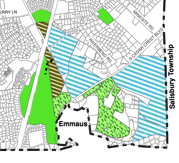
Township Official Map. Blue slash areas are “lands to be acquired for farmland or open space”. Brown slash area “for parks”. The Dorney tracts are pictured here along Lower Macungie Rd.
My thoughts: We would love to preserve this property, it’s listed on the Township Official Map and we stand ready to explore options with the landowner if any opportunities present. At this point the price is well above market value. Should this change we remain interested in continuing discussions. We would explore the same mechanisms we used to successfully preserve other large parcels.
The land south of Lower Macungie Rd. could be used to expand Camp Olympic Park allowing for driveway access off Lower Macungie Rd. Currently, the park can only be accessed off of Cedar Crest. This is not ideal from a safety perspective. So there is definitely a well defined public benefit for acquiring this particular parcel or preserving with a driveway easement. The areas north of Lower Macungie are prime agriculture lands currently being farmed. Altogether there are 6 main parcels that range from 7 to 40 acres. Some of the smaller ones are wooded lots. Altogether they total about 100 acres.
How it could be developed:
The property is zoned Suburban and has been for a long time. This could be developed with single family homes. Worse case scenario the properties could be developed with around 100 homes conventionally. However, this number is unlikely based on most recent precedents. For example, Commissioners would likely require the maximum amount of open space in any development proposals as opposed to a fee in lieu of. We have also not been inclined to take on additional public infrastructure obligations that we are not obligated to. This means a developer will have to account for these items without expecting any subsidies whether direct or indirect from taxpayers. Personally, I am very concerned about the impact any development in this area would have on Cedar Crest Blvd. Another reason we would love to pursue preservation. If that isn’t possible, ideally a developer would utilize conservation cluster design similar to Stone Hill Meadows which could result in some preservation even with a development scenario.
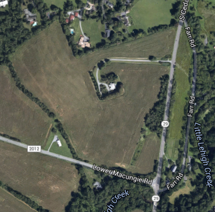
2.) Farmland along Cedar Crest and Lower Macungie Rd. “The Farr Tract”.
Overview: This 54-acre property was previously owned by Lehigh Vally Hospital in partnership with a family trust. A few years ago, the township indicated an interest in making an offer to permanently preserve the property at fair market value in conjunction with the Wildlands Conservancy. A letter of interest was sent. I supported this. Unfortunately the hospital and trust instead chose to sell to a developer.

The “Farr Property” is located on Cedar Crest and Lower Macungie Rd. The township was interested in preserving it along with the Wildlands conservancy. Unfortunately, Lehigh Valley Hospital and the family trust sold it to a developer instead of the Township/Wildlands. This was very disappointing as we would have matched the price. This area of Cedar Crest Blvd. is listed as a PennDOT congested corridor.
My thoughts: PennDOT currently lists South Cedar Crest Blvd. as a congested corridor. This is a big reason why the township had wanted to limit development at this location. The potential partnership with the Wildlands made sense because of proximity to the Pool Wildlife Sanctuary.
Again, all these conversations ended when Lehigh Valley Hospital and the Farr family trust chose to sell it to a developer for $1.75 million instead of to the township. You can read about it here. This was extremely disappointing. It’s very likely the township would have matched the sale price in an effort to preserve the property.
How it could be developed: Previous sketch plans were submitted that had 2-3 acre estate lots. If we could not get the property preserved, this was a desirable alternative in terms of impact as it kept traffic counts low. This does not seem likely anymore as the current owner who is a developer will probably want more units. The worse case scenario could be 80+ single family units. This would be tough since the township would require maximum open space for any conventional project as opposed to any fee’s in lieu of. (this would be my position). This property is also constrained because it has severe access issues so it’s unlikely PennDOT would allow a high volume driveway on Cedar Crest.
The bottom lines is after this property was sold by the Hospital/Farr family estate to a developer instead of the Township/Wildlands the writing was on the wall that it was going to be developed. The question is how intense and of what quality?
3.) The “Home Depot” aka the “Macungie Crossing” site.
Overview: This is a 4-acre commercial site on Hamilton Blvd. Prior to the recession, it was supposed to bring a Home Depot and up to five other tenants just east of Grange Road. A prior Board of Commissioners approved developer RD Management’s subdivision plan in 2007. A traffic light was even installed at Hamilton Boulevard and Shepherd Lane. Today the developer is simply holding the property as they are recieving a stable income from a Home Depot lease. The developer won’t divulge how long the lease is for.
My thoughts: I don’t expect this to change anytime soon. For now I’ve been told by commercial brokers that since Hamilton Crossings opened the township is now slightly “over retailed”. Specifically, in terms of lower value strip and box retail centers. This paired with a decline in general with that particular type of brick and morter shopping. If those trends continue I’m thinking and actually hopeful that the market dictates something higher value with more employment for this location in the future. It’s my opinion that box retail would be a waste of important real estate in the middle of our breadbasket commercial corridor. The site also doesn’t really lend itself to strip or box retail because the buildings would be hidden by the topography. These types of retailers want maximum visibility from main roadways.
How it could be developed: Right now because of prior approvals this is a turnkey project for previously approved box and strip retail. The township would only review building permits. The footprint for the previously proposed Home Depot was over 100k sf. Other outparcels range from between 2000 and 20,000 sf.
3.) Corner of Brookside and Lower Mac Rd.
Overview: This 16-acre site is zoned for mixed use development. It’s owned by the same family who sold the Weiner farm to the township for preservation. This tract was not included in that deal, so it will be developed. It was rezoned in an effort to preserve the character of nearby East Texas one of the oldest residential areas of the township. Note it’s small size compared to the 190-acre farmland tract that was preserved.
My thoughts: This property will be developed. Likely within the next few years. The family preserved the nearly 200-acre tract they owned down the street which could have been developed with 300+ homes. This was the townships #1 concern. And we’re thankful to them for working with us to preserve it. It’s clear they desire to cash out on this smaller property which is their right as landowners. And from my perspective this one makes alot more sense to develop than the farmland piece that was preserved. The family has worked with us to submit a sketch plan that represents a shared vision for a low impact development compared to what they have asked for in the past.
This sketch plan was favorably reviewed by the planning commission for this site. It includes neighborhood scale commercial and high quality townhomes.
How it could be developed: In the past the owners have tried to develop things like a very large supermarket and box retail. Two things our planners felt are far too intense for this corner.
This article has an excellent overview of the history of the site and also includes an overview of the current village ordinance in place. The sketch plan which was favorably reviewed by the planning commission includes smaller scale neighborhood commercial and very high quality town homes. The ordinance for the property requires things like intense landscaping, boulevard streets, walkability and high quality design. This model ordinance overviews the concept and includes many examples of what the goal is.
4.) “Faith Church Property” (Brookside and Lower Macungie Rd.)
Overview: When folks ask about this property they are generally referring to what’s actually 3 properties. Two are owned by Faith Church. A 3rd by another private landowner. They total about 50 acres altogether of developable land in the Suburban zone. This means single family homes can be developed. This property was originally slated to be an expansion of Faith Church. This is why the frontage has been improved with a “driveway to nowhere”. At some point the Church decided not to carry out those plans. Today, they are interested in selling the land and are actively marketing it. It needs to be noted this land is severely constrained with a combination of powerlines and floodplain. Much of the 50-acres isn’t developable. I want to note also, Faith Church is a wonderful community partner. They have a fiduciary responsibility to their congregation but they also are very much aware of the townships land use goals. We have met with them on numerous occasions.
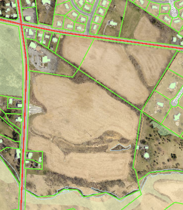
This photo shows the property lines. The “Faith Church” property is actually 3 parcels. 2 are owned by the Church. The 3rd another private party. They are on the corner of Brookside and Lower Mac Rd. (on the Italiano Delite side)
My thoughts: This property is not on the township official map and therefore not a formal prospect for preservation. However, this could change now that the #1 and #2 priorities have been preserved. This property simply wasn’t as important (due to a combination of factors) to preserve as other much larger properties. Again, this mindset could change. And I want to again point out that Faith Church is a wonderful community partner. As staff continues to have discussions with them opportunities to preserve this might materialize. I support exploring any options out there.
How this property could be developed: Note again, that the development potential is limited because of the river and the powerlines. The property is currently being marketed. However, I believe the price tag is very high for what could actually be built by right. Single family homes could be built here but the number would be pretty low due to the constraints and the townships mentality regarding taking more infrastructure and requirements for open space. There have also been some ideas floated for an end user that would be very community beneficial in the category of private recreation. This is something I would certainly support.