The Movie Tavern. Cleaning out the notebook.

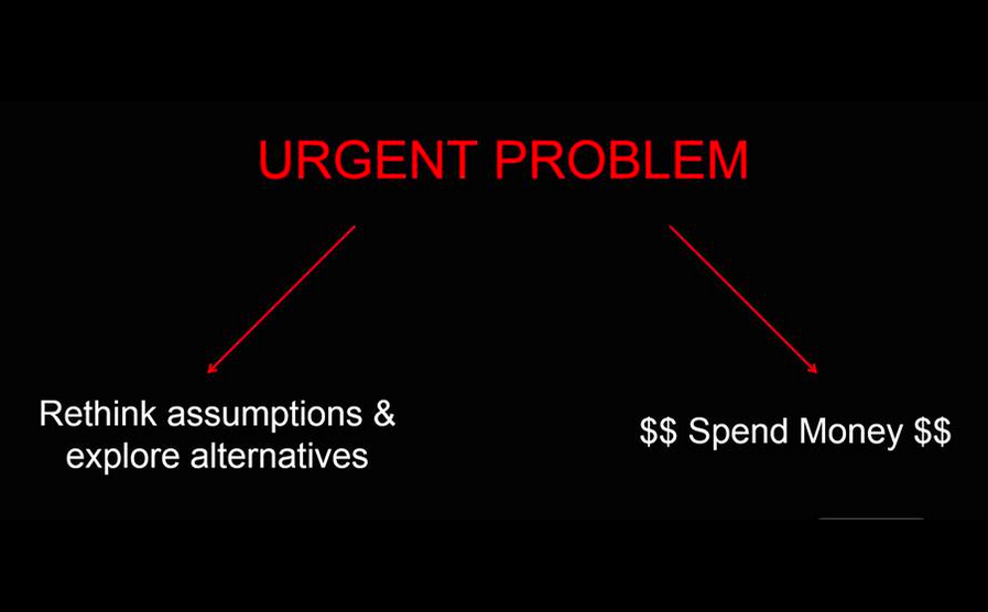
Clearing out my notebook on the Movie Tavern (Trexler Business Center) – I hope this is helpful for folks to understand why I voted NO. The plan passed 3-2. This one was a long slog. It was unfortunate it turned out that way. It didn’t have to be but certain developer concerns about the impact fe were raised very late in the game. 

1.) First, I apologize I wasn’t able to blog more about this topic over the last few months. Problem was for the last few weeks of this issue we were under the implied threat of litigation. Unfortunately, at that point a blog meant to keep residents informed can be used against the township in a court. Once we have the threat or implication of legal action we lose some of our ability to talk freely about a subject. This is unfortunately reality. In cases of land development reviews words can be taken out of context, mischaracterized or misrepresented. I struggle with this. I’m often advised “not to blog so much”, but I fundamentally believe residents should know every piece of information I know. My blog let’s me clearly put my thoughts down “on paper” in writing. The free flow of information is critical to transparency.  Unless forced to I’m not inclined to ever compromise that. Hence clearing out the notebook now.

2.) I would have voted yes on the original resolution. The original resolution left a blank space for the amount of credits granted. During the course of consideration 3 credits were agreed upon by the planning and zoning committee and the township engineer and staff. These were negotiated during the course of public meetings. I felt they were fair and I felt they honored the intent of the traffic impact fee by addressing regional issues related to the project. The problem with the resolution presented to us the AM of the vote was that additional credits were granted. These were not subject to public discussion in a meaningful way.

3.) Credits, vs. contributions vs. impact fee monies. The impact fee – “Transportation impact fees are a funding mechanism permitted by the Pennsylvania Municipalities Planning Code (MPC). Fees can be assessed to new development in proportion to its impact on transportation networks—the traffic the development is expected to generate during peak commuter periods. Funds collected are used to improve roadways used by development-related traffic.” PennDOT impact fee guidebook.

That is the purpose. However, I believe the program the way it’s written has some severe flaws. In light of that I am OK with credits to appropriate off site improvements. Using the same definition of off site improvements as the impact fee program. And also gaining the same amount of monetary value as the impact fee program allows. No more, no less. This is very fair and very transparent.

Again, I had no problem with crediting or contributions in liu of impact fee. My problem is we gave additional credits beyond what was agreed upon during the course of public meetings. I also had issues with the credits themselves in that I feel strongly they don’t address issues that would have otherwise been addressed by developers at some point in the future.

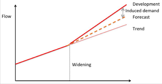
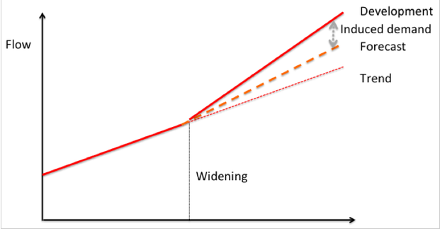
4.) My structural problem with the last minute credits. The last minute credits were basically to fund a new driveway across the street (north side of the blvd.) that will connect Hamilton Blvd and Grange Rd. Now, there are benefits to this and that’s the reason why have it on the township official map. But the map gives us the tools to ensure this conversation happens at an appropriate time. That is in the future when it’s actually needed. (If and when the north side develops, remember the intent of the impact fee is not to address or otherwise induce future development). The problem here is this credit is unrelated to the Movie Tavern project. Further there is no timetable when it ever gets built. And it’s something we would likely secure anyhow based both on our ordinances, the official map and realities of any commercial project built on the north side of the boulevard. 

In my opinion, we gave away something that made no sense to do so at this time meaning we left money and value on the table that we should be using to fix existing issues. Not future issues related to more development. I actually believe the townships move last night will expedite and induce more “boxy” development on the north side since it will give future developers more public road frontage. I also question whether the township is obligating ourselves to essentially take ownership of what otherwise would and should be a private shopping center driveway on the north side. If this is the case it’s a strategic error.

5.) Procedural problems with the last minute credits. As mentioned above, there were a number of credits and contributions agreed upon in the course of public meetings. They were presented and vetted in public. They addressed the intent of the traffic impact fee ordinance. I had no problem with this. Issue was, that this still left an approximate 375,000 dollar hole. This hole was “plugged” apparently 24 hours before the final vote. I have an issue with that. So did my father Ronald R. Beitler. The two reasons above including both the structural and procedural issue with the “last minute” credit are why I voted NO on the resolution.

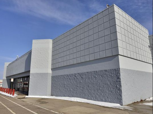
6.) The land development itself is good. I am 100% in favor of preservation and better managing growth. Problem here is this development is proposed in a location identified for growth. Other areas of the township not we are aggressively pursuing preservation strategy. And we’ve had successes. This was not a place that made financial or planning sense to do so.

I do wish this wasn’t another strip and pad project, but for what it is – much like Hamilton Crossings – it’s of a higher quality. I wanted to give specific credit to the Movie Tavern for working with us. They voluntarily upgraded many facets of the plan that will result in a better overall project. They also worked with us on a compromise regarding the tower height. Resident concerns were valid, and the Tavern addressed them. The developer also did work with us during land development although at times we had to push them a little harder. Everything was a negotiation. The Movie Tavern was easier to work with since they understood a better project was better for their business. It was less a negotiation and more working together to build something neat. They seemed to understand the vision we are trying to accomplish on the boulevard. That buy in was important.

7.) The Movie Tavern in and of itself was a good fit. While our job is not to pick winners and losers in terms of uses based on opinions. It is to vet projects based on objective criteria. In this case based on the objective criteria of traffic counts – the Movie Tavern was a much better fit than what otherwise could be built here. The reason is traffic counts generated are off peak. Nights and weekends. Again, the theater will not generate trips during AM or PM peak hours. This was a huge advantage to the township.


Mission creep in preservation efforts.

Over at ramblings Bernie is writing a series on issues that arise when otherwise well intentioned open space preservation programs experience mission creep. Good stuff. Brings up lots of very good points.

“Northampton County’s Open Space program is designed for farmland preservation, environmentally sensitive land and municipal parks. Like kissing babies, it’s politically popular. In many instances, it is also the right thing to do. But there have been questionable decisions like the preservation of cliff lands and swamps that could never be developed…”

There are many reasons to preserve open space. The one I focus on and that you would think all should agree on regardless of political persuasion is keeping taxes low. Want to keep taxes low? Preserve farmland.

When a local program strays from a focus on the preservation of developable properties – preferably actively farmed since it’s a form of industrial infrastructure – there is potential for mis-use of public funds. The number one criteria should be preservation of developable land where otherwise low value land uses like warehouses could be built. In other words land uses that do not provide a net financial gain for localities and generate very few jobs/acre and low revenue/acre vs. the new taxpayer funded long-term municipal liabilities created.

Preservation of natural resources is also a worthy goal. But I’m convinced the priority for local municipalities should be developable properties and farmland since you can justify use of tax dollars with lifecycle cost analysis of farmland vs. the alternative. There are other programs and ways to preserve the natural resources.


Assessments for calculating property taxes.

After a meeting where the township blindly took on another long term financial obligation to maintain a storm water basin with zero accounting of the real dollar costs…It’s clear the township needs to bring in a professional consultant who does lifecycle value per acre evaluation if we cannot do it consistently in house. We have to make officials responsible for choices they make by demonstrating clearly long term impact. My friend and former Commissioner Deana Zosky was the first and only person who talked about this kind of stuff in Lower Mac. Economic growth should build on a foundation of understanding the tax implications of differing choices. We do not have that foundation today and it was on full display last Thursday.

Screen Shot 2015-06-20 at 12.23.25 PM

As I write often here, we rarely don’t at all consider land uses in terms of the value/revenue vs. the financial liabilities the taxpayer assumes. The calculus often gets muddled since the school district would love for us to chase certain types of low value greenfield development since it’s “windfall” for them. To that end EPSD is about to sell a chunk of land for low value strip development off Lower Mac Rd. (in part we are to blame since our urban zone allows poor built form) End of the day though, can you blame the district? It’s a logical reaction to a broken system with systemic problems including but not limited to pensions, inconsistent state funding etc. Most of all however it’s the fact the municipality has to pay for municipal services. Not the district. These include roads, stormwater, public safety etc. The township takes on the obligation to provide all this. So with every low return greenfield development the district gets the unencumbered windfall but the township gets the long term financial liabilities. It very much is a rob Peter (township) to pay Paul (EPSD) scenario. Even bigger picture, the windfalls really amount to nothing more than band aids as long as we keep our heads buried in the sand and do not address underlying issues. (enter dog chasing tail visual) But back to topic. . .

Looking exclusively at municipal side. Municipal residential taxpayers are the ones who really get throttled in our system. It’s amplified when we do not account for lifecycle costs. The way we calculate assessed values is one more of many fundamental issues. Assessed value determines what your property tax burden is. In the system we have today there is a fundamental in-balance in terms of how much responsibility is shouldered vs. impacts created. 

Think about this for a second:

An average single family home in a subdivision in Lower Mac:
(used an average assessed house on wheatland dr. as example)
Square feet: 2,128
Assessment calculated at: $256,700
This means the homeowner pays about 120 dollars in assessed value per SF

Example of an existing warehouse in the township:
Square feet: 1,000,000
Assessment calculated at: $24,100,000
This equals 24 dollars in assessment per SF

So basically, a residential homeowner is paying 6X the tax liability per square ft vs. a warehouse. This is insane. A residential single family home maybe generates 4-6 car trips a day. Sits on maybe an acre of land. Compare to warehouses that generate massive public liabilities, create mind boggling amounts of traffic, huge amounts of storm water discharge, require super-sized – and massively expensive road improvements – and most disturbing each million plus warehouse churns up 60 acres of land. In Lower Mac’s case prime farmland. All while generating extremely low jobs and revenue per acre vs. other more community friendly neighborhood commercial uses.

The problem is an assessment calculation system that heavily weights market value as a determining factor. Market value has little to nothing to do with impact. Why should a homeowner be punished for adding a deck? Does that somehow increase the amount of traffic your home generates? The amount of stormwater? The kids you have in the district?

When you dig into this it’s maddening. It is a totally broken and backwards system where the highest liability land uses pay the least amount in taxes apples to apples in relation to the impacts they create. Road wear and tear. Stormwater run-off. Public responsibility to maintain infrastructure. Muni services. Again, this is top of mind since we just blindly took on a new storm water basin with ZERO information about long term costs. A stormwater basin that would have never existed in the first place had the township been able to maintain it’s growth boundaries of the 80’s. Now that we have it I’m interested in how we pay for it. That’s what this conversation is all about. What land uses shoulder the burden.

As I always ask: Whose subsidizing who?

It’s not just about fundamental in-balance. Again, in the current system if you take a dilapidated building and fix it up. Or start a business and consider converting to commercial. What happens? You get punished for it tax wise. But the greenfield developer who gobbles up huge amounts of land, requires new public infrastructure, creates very low jobs/acre and revenue/acre vs. other other massive liabilities. They get rewarded.

RELATED: Gaming the system makes it worse – Big Box stores ringing up property tax discounts.

There are very real underlying financial issues where the deck is stacked in favor of greenfield development and other stealth subsidies that drive sprawl. The way we calculate assessments is one aspect. We need to calculate assessment based on land + Impact. Not buildings or building improvements or building quality.


Big Box becoming more of a terrible deal.

From the Institute for local self reliance: About ILSR
For Cities, Big-Box Stores Are Becoming Even More of a Terrible Deal.

#DoTheMath – Couple of takeaways from this:

1. We have a potential dark store issue in Lower Macungie. Since.

It’s an established part of the big-box retail model that the boxes themselves be custom-built, cheaply constructed, and disposable. If retailers decide that they need a bigger space, it’s cheaper for them to leave the old one behind and build a new one.

This is happening in Lower Mac right now with Weis. They are currently in the process of abandoning their current store to build a new one – across the street. This opens the possibility for Weis to argue the “dark store” method for calculating tax assessment.

Screen Shot 2015-06-18 at 10.37.28 AM

2. Even without assessment reductions box retail isn’t a fiscal winner for local communities. The reduction strategies happening in some states just make it worse.

When eight communities in central Ohio looked at the fiscal impacts of big-box retail, they found that the stores actually demanded more public services than they generated in revenue, and created a drain on municipal budgets to the tune of a net annual loss of $0.44 per square foot, or about $80,000 for a typical Walmart supercenter. 

Mark my words, our increasingly boxy/strippy Hamilton Corridor will be the driver for local police and a massive unavoidable tax increase: 

“Higher demand for police departments is one example. In Port Richey, Fla., nearly half of the town’s crime emanates from the area Walmart. “The taxes that come from Walmart are not even enough to cover two police officers’ salaries,” Police Chief Robert Lovering told Vice.”

It’s happening in Lower Mac today.

3. With Hamilton Crossings we are beginning from an even bigger hole. Throughout the HC discussion it was parroted that the windfall was worth the tax gimmick. The narrative was: “There is nothing now, when something is built we can tax it”. Problem is what we approved costs us much more then what’s there now – fallow open space. And the new tax revenue won’t cover the long term liabilities. Our problem is the fatally flawed short term way we look at municipal finances.

“Cities and towns continue to buy into myths sold to them by the mega-retailers themselves, that big-box stores spark economic development. In service of this myth, local and state governments across the country have granted at least $2.6 billion in subsidies to just six large retailers, including $160 million to Walmart and $138 million to Lowe’s, according toanother study from Good Jobs First.  That’s without factoring in the cost of services, which as Marquette, Mich., saw, can pile up”

We got to start thinking beyond the windfall and look at lifecycle sustainability. That is: Lifecycle costs (liabilities) vs. revenue (tax base). I am not arguing for a valuable corridor to be vacant. This isn’t about NIMBY. My argument is a financial one. We need to build better. Smarter. Patterns that create positive value. But since at least with Hamilton Crossings that ship has sailed….

4. Living in reality. What’s done is done.  Can’t change the fact 3 members of the current BOC opted to hand out a 20 year tax subsidy. So, moving forward our strategy has to focus on repair and triage. We accomplish that with balance. First by preserving farmland and open space concentrating on places where expensive infrastructure would have to be built and maintained by taxpayers to support greenfield growth.

Second, we encourage better/smarter growth in patterns that creates higher value in locations where infrastructure exists. We get there by fixing our terribly archaic and restrictive zoning code. By instituting aspects of a form based code we allow and even incentivize more “Main Street” oriented walkable neighborhood mixed use devleopment on Hamilton Boulevard.

The land development alternative – What does that mean? Lower Mac is working on a vision.  Here is an outline: Lower Mac’s Hamilton Corridor vision study. If we adopt and follow this plan we will induce more high value growth on Hamilton Boulevard. This is essential to balance the low value. More positive growth will help balance the net negative financial development.

“Locally owned retailers provide value to a community in many ways, but one of them is to the municipal accounting books. In a study that found that big-box retail generates a net deficit for taxpayers in a Massachusetts town, the researchers also discovered that specialty retail, like Main Street businesses, are the ones with a positive impact on public coffers, generating more revenue than they require to service.”

One thing to watch is avoiding falling into the pitfalls of “smart growth light” like we have in the past. #WordsHaveMeanings.

Screen Shot 2015-06-18 at 10.49.55 AM

The taxing alternative – Shift the burden off residents and onto warehouses and box stores.

Do cyclists pay their fair share?

I have to applaud PennDOT efforts to raise awareness about cycling on the road network lately. In PA, on our roadways responsibility is a two-way street. Both cyclists and motorists need to be aware of and follow the rules of the road relating to cycle safety.

Last couple months I’ve noticed once a week PennDOT has been making really nicely crafted social media posts aimed at cycle law awareness issues. Here is an example:
Screen Shot 2015-06-03 at 12.26.23 AMUnfortunately whenever a post like this is made a very small but vocal and extremely uninformed minority of commenters always follows with a litany of silly posts.

One of the most common and most uniformed narratives is usually along the lines of: Cyclists should have to pay for plates, registration, inspection and insurance like every other vehicle on Pennsylvania roadways“. 

Couple problems with this sentiment:
First, cyclists do pay their share. Actually they pay a far disproportionate share. Here are the facts:

  • User fees (license, registration etc) pay for only 34% of the costs of roads in Pennsylvania. The rest comes from general funds that cyclists also pay for.
  • 80% of cyclists also own cars so 80% also pay the user fees associated with those cars.
  • A bike has 1/20th the impact of a car on the roadway. This includes funding for bike facilities. (which usually just involves moving paint around)

Essentially, when a motorist makes the decision to bike instead of drive they are saving us ALL. Because 1.) They also pay the bulk of costs to maintain roads. Pair this with 2.) bikes require significantly less expensive specialized facilities and 3.) cyclists create a fraction of the impact.

So basically, as a driver and taxpayer… next time you see a cyclist take a moment to thank them. They are mathematically doing their part to keep your tax burden lower in a number of measurable ways. If it were a fair world they should probably get a rebate for cycling since they save everyone alot of money when they ride.

Lower Mac to consider borrowing for open space preservation.

I support preservation of farmland & open space prioritized by parcels with high development pressure. While debt isn’t my preferred means to accomplish this I support whatever consensus the board arrives at since I feel strongly about the long term benefits. I also understand we have a voter mandate for preservation.

*Note: I have over the past year proposed alternate funding strategies including:
1. Ear-marking developer transfer taxes for preservation
2. Creating a transferable development rights program (TDR). TDR is a free market mechanism for preservation. It involves no township money.
Unfortunately, neither got traction from other board members. 

In March Commissioners Conrad & Lancsek proposed borrowing to fund preservation. While I am pleased it appears the entire board is willing to settle on a mechanism I am only cautiously optimistic at this point. Read about the proposal here.

First, let’s talk mandates. I came into office with 2. Important to remember, since both relate to preservation.

1. First keep taxes sustainably low. Meaning setting us up for long term resiliency as opposed to gimmicks. I think I’ve delivered with the homestead exclusion that rollled back 25% of the prior boards tax increase for homeowners. More importantly relating to resiliency it sets us up to capture more revenue from commercial and industrial users (strip malls and warehouses). These uses generate more liabilities than revenue. Addressing this disparity sets us up for a more sustainable long term balance sheet. High liability land-uses should carry the burden. Not residents.

2. Second I came into office with clear mandate from voters to preserve farmland and developable open space. This also relates to #1. How to keep taxes low in Lower Macungie.

So why only the cautious optimism about the bond?

I’m nervous that some might see a 10M bond as a “blank check” for whatever pet project is the flavor of the moment. With the “blank check” mentality we can get lazy. That scares me.  Remember, the reason the prior BOC raised taxes in 2012 was to fund capital projects. Fact is since then, the largest single project moving forward is the 4.9 million dollar quarry park renovation including over 1.5M earmarked for turf fields. Hardly a priority and certainly not warranting a tax increase.

I’m nervous we’ve diluted a conversation about funding open space (something with clear long term financial benefits) with “other capital projects”. (Things that might not)

I’m also leery of inducing more “dumb growth” with STROAD infrastructure. While it’s important we solve existing traffic problems we have to be careful not to induce further congestion. (see graph below)

So, lets proceed but with caution. Any questions about the potential bond please feel free to email me at ronbeitler@gmail.com

What is induced demand.

The red line represents vehicle flow along a given road. Traffic steadily rises until someone decides the road needs to be widened. Then the original trend line (dotted red) gets replaced with an even greater travel forecast (dotted orange), as we'd expect by creating more road capacity. But the actual new level of travel developed by this widening (solid red) is even greater than the forecast predicted.

The red line represents vehicle flow along a given road. Traffic steadily rises until someone decides the road needs to be widened. Then the original trend line (dotted red) gets replaced with an even greater travel forecast (dotted orange), as we’d expect by creating more road capacity. But the actual new level of travel developed by this widening (solid red) is even greater than the forecast predicted.

Conservatives – We need to avoid hypocrisy.

Why on earth is the Texas legislature considering a bill to “hobble” a private companies effort to build a critical high speed rail connection in Texas? Kind of mind boggling. Anti competition, anti market.. Especially considering the private company has vowed not to take a dime of public money. And by building this rail line the company helps Texas avoid dumping countless millions into massively subsidized highway improvements.

Here is the issue: A private company wants to finance a bullet train to carry passengers between Houston and Dallas in less than 90 minutes. The company undertaking the project has said it hopes to have the train running by 2021 and has vowed to not take any public subsidies. Texas Senate Bill targeting bullet train project advances.


As usual Strongtowns nails it:

“Texas is known for its commitment to limited government, individual responsibility and personal liberty. At least it likes to think of itself that way. When it comes to transportation — specifically automobile transportation — Texas is one of the most socialist states in the country, taxing and spending at amazing rates with an additional predilection towards borrowing enormous sums of money to build even more government-backed infrastructure.

I thought us Republicans were all about competition and the free market? I know that I believe in those things? So what’s the issue? Turns out to be eminent domain. Ok, I get that.

But here’s where the hypocrisy comes in. I wonder if the Texas legislature has the same mentality with the Keystone pipeline (also for profit venture) and eminent domain? Taking the eminent domain issues off the table, I have mixed feelings on the pipeline project. What I do know is I can’t stand hypocrisy. And that’s exactly what I’m smelling out of the Texas legislature.


Currently, hundreds of private firms have eminent domain authority in Texas, including pipeline companies, utility companies and telecommunication firms. More than a dozen private railroad companies also have that authority, according to an unofficial list maintained by the state comptroller.

What about if the proposal was a new massively taxpayer subsidized highway that required eiminent or STROAD widening project that involved a taking? Legislators would probably fall over themselves to support it. Can we please avoid cherry picking and applying our conservative principles evenly? We aren’t in the business of picking winners (taxpayer subsidized highway and air lobby) and losers (in this case privately funded rail)

Hypocrisy. Can’t stand it.. Throw in the immensely powerful and massively taxpayer subsidized highway lobby. (Airports also). Very smelly.

This is exactly what we need in the US. Private companies can make passenger rail profitable. The key? SPEED.

STROAD DYNAMICS IN GRAPH FORM

Here is a diagram from Strongtowns post called STROAD dynamics. It was created by a planning firm called Design Rochester. I just expanded on it a little bit to show the safety correlation and photos.

This sums up the way we need to look at the Rt. 222 Bypass and Boulevard from a context sensitive standpoint.

STROAD DIAGRAM

Pedestrian fatality epidemic

This week we had another local tragedy involving a pedestrian on a STROAD. We have a national epidemic of pedestrian deaths in this nation. And unfortunately Pennsylvania is heading further backwards.

According to the Governors Highway Safety Association Pennsylvania had the second highest increase in pedestrian deaths from 2013-2014:

Screen Shot 2015-03-18 at 1.01.46 PMHere in the Lehigh Valley a woman lost her life walking on the shoulder of Airport Rd. when she was hit by a drunk driver. The drunk driver will be punished as he should be. But the local officials, planners and engineers who designed and allowed a dangerous STROAD that mixes restaurants, movie theaters, pubs and retail (things people want to and should be able to walk to) with zero pedestrian accommodations will not.

This death like most could have been prevented through better policy, design and practice. There was a crosswalk near this accident because it’s mandated by the state. But like most STROADS there are no sidewalks or any facilities at all to get people from places of business safely to the crosswalk. In fact, the whole environment was built to be completely abrasive and dangerous for anyone not inside a metal cage. So, people react naturally and they walk on the dangerous shoulder.

More than half of all pedestrian fatalities occur on arterials, and over 60 percent of these tragedies occur on roads with speed limits of 40 mph or higher. These are the STROADS. Here in Lower Macungie Brookside Rd., Lower Macungie Rd., the “bypass” and Hamilton Boulevard are all STROADS. Locally, along these STROADS we have built a library, pool, parks and schools. We’ve zoned for places of business including daycares, restaurants and retail. Naturally, people want to be able to and should be able to walk to these destinations. If we continue to plan to put commercial uses on these roads, we need to expect people will walk and bike on them and design accordingly.

This includes:
Bike Lanes
Sidewalks
Pedestrian scale road geometry
Appropriate design speed that correlates with appropriate posted speed
Context sensitivity: Neighborhood commercial form, street trees, etc.

STOP #dangerousbydesign

STROAD DIAGRAM


LMT Traffic woes: What is induced demand. Why does it matter.

Flow and efficiency over a larger grid/network and smarter growth land development are much better ways to address traffic issues than mindless capacity “improvements” in the name of “safety”. (without quantifying exactly how certain projects make roads safer)

The red line represents vehicle flow along a given road. Traffic steadily rises until someone decides the road needs to be widened. Then the original trend line (dotted red) gets replaced with an even greater travel forecast (dotted orange), as we'd expect by creating more road capacity. But the actual new level of travel developed by this widening (solid red) is even greater than the forecast predicted.

FROM CITYLAB The red line represents vehicle flow along a given road. Traffic steadily rises until someone decides the road needs to be widened. Then the original trend line (dotted red) gets replaced with an even greater travel forecast (dotted orange), as we’d expect by creating more road capacity. But the actual new level of travel developed by this widening (solid red) is even greater than the forecast predicted.

As Citylab so aptly puts it, in other words, widening a road invites more cars onto it. This concept is called induced demand. And it’s an expensive circular trap that municipalities fall into far too often. The joke of course being “adding lanes to cure congestion is like loosening your belt to cure obesity.”

How do we break the pattern? I’ll use another chart I’m a big fan of. .
Screen Shot 2015-03-09 at 10.39.46 AMAs a community the default is usually $$spend money$$ or in our case throw money at a problem. Usually this involves doubling down on sprawl ponzi scheme solutions that got us into messes in the first place. This includes turning lanes and widening projects and generally slamming highway geometry onto our local road network.

This whole notion of induced demand is relevant today locally (as twp. considers throwing money at intersections) but also regionally (Highway Rt. 22 widening).

Now, Highway Rt. 22 has to be addressed. No doubt. The problem is self created by our focus on a logistics warehouse economy over the years. But the solution cannot be widening alone. Widening is a temporary at best solution. A band aid. (in this case a billion dollar band-aid….) The solution has to be comprehensive.

Same thing locally, we can’t just throw money at intersections alone and expect not to be dealing with the very same intersection 10 years down the line.

A next level approach example would be Rt. 222 (bypass) where I’ve been a advocate for grade separation. This is beyond simply widening. In that case an exercise in STROAD repair means taking out the signals to increase flow and raise the speed limit. Big picture on the Rt. 222 corridor we address congestion by making sure the Boulevard is contextually a Boulevard, and that the bypass actually functions as a bypass. STOP building STROADS. What is a STROAD?

Transportationist: Elements of access – Induced Demand